Current Research Projects
The palette of research questions that we are currently entertaining are listed below and are broadly focused on understanding the dynamics, variability, and predictability of antecedent environments and flow evolutions that are conducive to the production of high-impact weather events. To address these research questions, we employ a multi-scale approach using a combination of long-term reanalysis datasets, operational and idealized model output, and representative case studies. By investigating the antecedent environments and flow evolutions associated with high-impact weather events, as well as their relative forecast skill, these research efforts offer the potential to better inform forecasts of high-impact weather. Furthermore, the results from these research efforts can be employed to investigate the degree to which the frequency and characteristics of large-scale flow patterns associated with high-impact weather events vary within future climate simulations.

|
North Pacific Jet Regime-Dependent Predictability
Previous studies have identified the leading modes of North Pacific Jet (NPJ) variability that prevail on synoptic time scales during the cool season. The first mode corresponds to a zonal extension or retraction of the exit region of the climatological NPJ, while the second mode corresponds to a poleward or equatorward shift of the exit region of the climatological NPJ. These NPJ regimes can strongly influence the character of the large-scale flow pattern over North America. Consequently, knowledge of the prevailing NPJ regime and the forecast skill associated with each NPJ regime can add considerable value to operational temperature and precipitation forecasts over North America. Motivated by the relevance of each NPJ regime to the character of the large-scale flow pattern over North America, the two leading modes of NPJ variability during the cool season are used to construct a NPJ Phase Diagram. The projection of 250-hPa zonal wind anomalies at one or multiple times onto the NPJ Phase Diagram subsequently provides an objective characterization of the state or evolution of the upper-tropospheric flow pattern over the North Pacific. Winters et al. (2019) perform a 30-year analysis of GEFS reforecasts with respect to the NPJ Phase Diagram. The results suggest that forecasts verified during jet retraction and equatorward shift regimes are associated with reduced medium-range forecast skill compared to jet extension and poleward shift regimes. Furthermore, an examination of the best and worst medium-range forecasts suggests that periods characterized by rapid NPJ regime transition and the development and maintenance of North Pacific blocking events exhibit reduced forecast skill. This work is supported by the National Oceanic and Atmospheric Administration via Grant NA15NWS4680006. |

The NPJ Phase Diagram

Composite 250-hPa wind speed (purple shading), 250-hPa geopotential height (black contours), and 250-hPa geopotential height anomalies (contoured in solid red and dashed blue for positive and negative anomalies, respectively) 192 h after a best or worst NPJ Phase Diagram forecast is initialized during each NPJ regime. Figure and caption adapted from Winters et al. (2019).
|

 Northern Hemispheric map of tropopause height (black contours) at 0300 UTC 1 Jan 1956. Areas characterized by a strong gradient in tropopause height are synonymous with the locations of the polar (POLJ) and subtropical (STJ) jet streams. The area denoted with a circle is a region characterized by a jet superposition. The green shading corresponds to the tropical tropopause, white shading to the subtropical tropopause, and red to the polar tropopause. Figure and caption from Winters and Martin (2014) and modified from Defant and Taba (1957). Northern Hemispheric map of tropopause height (black contours) at 0300 UTC 1 Jan 1956. Areas characterized by a strong gradient in tropopause height are synonymous with the locations of the polar (POLJ) and subtropical (STJ) jet streams. The area denoted with a circle is a region characterized by a jet superposition. The green shading corresponds to the tropical tropopause, white shading to the subtropical tropopause, and red to the polar tropopause. Figure and caption from Winters and Martin (2014) and modified from Defant and Taba (1957).
|
Polar–Subtropical Jet Superpositions Events
The atmosphere is often characterized by a three-step pole-to-equator tropopause structure with each break in the tropopause associated with a jet stream. While the polar jet stream and subtropical jet streams typically occupy different latitude bands, substantial meanders in their locations at any particular time are common. Occasionally, that latitudinal separation can vanish resulting in a vertical superposition of the polar and subtropical jet streams. Prior case study work by Winters and Martin (2014, 2016, 2017) demonstrates that jet superpositions are often attended by a dynamical and thermodynamic environment that is particularly conducive to the production of high-impact weather. As one example, Winters and Martin (2014) determined that the strengthened ageostrophic transverse circulation associated with a jet superposition facilitated an increase in poleward moisture flux that was critical for the production of heavy rainfall during the second day of the historic 1–3 May 2010 Nashville Flood. Research is ongoing to determine the characteristic relationship between jet superpositions and high-impact weather events. To the degree that a relationship exists, the identification of jet superpositions within medium-range forecasts may highlight time periods and locations that may be susceptible to the development of high-impact weather. This work is supported by an NSF–AGS Postdoctoral Research Fellowship (AGS-1624316). |
|
Antecedent North Pacific Jet Regimes Conducive to Extreme Temperature Events during the Cool Season
The occurrence of extreme temperature events (ETEs) during the cool season is often accompanied by considerable societal and economic impacts. Additionally, the development of one or several ETEs during a single season can contribute disproportionately to temperature anomaly statistics for that particular season. The disproportionate contribution of ETEs to seasonal temperature anomaly statistics suggests that ETEs need to be considered in order to understand the dynamical and thermodynamical processes that operate at the weather–climate intersection. Research is ongoing to identify continental U.S. ETEs and to classify the identified ETEs based on the antecedent state of the North Pacific Jet (NPJ) prior to ETE initiation using the NPJ Phase Diagram (see 'Weather Regime-Dependent Predictability' section). Results demonstrate that the preferred state and evolution of the NPJ varies considerably based on the location of ETE initiation and the meteorological season. The classification scheme is also employed to developed NPJ regime-based composites of ETE initiation in order to illuminate the variability in synoptic-scale flow evolutions that are conducive to ETE initiation. Winters et al. (2019) summarizes the results from this work. Additionally, the methods employed in this study are currently being applied to investigate antecedent environments associated with other types of high-impact weather events. This work is supported by the National Oceanic and Atmospheric Administration via Grant NA15NWS4680006. |
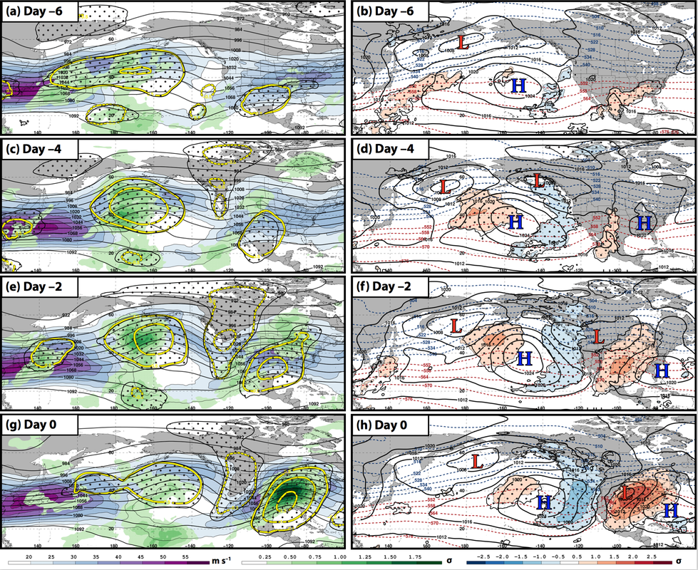 Composite synoptic-scale flow evolution prior to the initiation of a Southern Plains extreme warm event following a retracted North Pacific Jet. The left column shows the evolution of 250-hPa wind speed (purple shading), precipitable water anomalies (green shading), and standardized 250-hPa geopotential height anomalies (yellow contours) during the 6-day period prior to ETE initiation. The right column shows the evolution of mean sea-level pressure (black contours), standardized 850-hPa temperature anomalies (red and blue shading), and 1000–500-hPa thickness (red and blue dashed contours) during the 6-day period prior to ETE initiation. Figure and caption adapted from Winters et al. (2019). Composite synoptic-scale flow evolution prior to the initiation of a Southern Plains extreme warm event following a retracted North Pacific Jet. The left column shows the evolution of 250-hPa wind speed (purple shading), precipitable water anomalies (green shading), and standardized 250-hPa geopotential height anomalies (yellow contours) during the 6-day period prior to ETE initiation. The right column shows the evolution of mean sea-level pressure (black contours), standardized 850-hPa temperature anomalies (red and blue shading), and 1000–500-hPa thickness (red and blue dashed contours) during the 6-day period prior to ETE initiation. Figure and caption adapted from Winters et al. (2019).
|


Conceptual diagram summarizing the development of a jet superposition. The orange
arrows depict the branches of an ageostrophic transverse circulation, the green circle
identifies an area of convection, and the plus (minus) sign corresponds to the center of a polar
cyclonic (tropical anticyclonic) potential vorticity perturbation, with the blue (red) arrow indicating the
movement of that particular perturbation toward midlatitudes. The purple fill pattern corresponds
to isotachs, with the darker shade of purple identifying faster wind speeds. The
locations of the polar (PJ), subtropical (STJ), and superposed jets are labeled accordingly. Figure and caption from Winters and Martin (2017).
|
Dynamical Processes Supporting North American Polar–Subtropical Jet Superpositions
Prior work by Winters and Martin (2016, 2017) suggests there is considerable variability among the antecedent environments and dynamical processes that are conducive to the production of jet superpositions. Consequently, a comprehensive examination of the relative importance of dynamical processes that operate within the double-jet environment to produce North American jet superpositions is warranted. This study identifies North American jet superposition events during the 32-year period, 1979–2010. Jet superposition events are then classified into three characteristic event types: "Polar Dominant" events consist of events during which only the polar jet (PJ) is characterized by a substantial excursion from its climatological latitude band; "Subtropical Dominant" events consist of events during which only the subtropical jet (STJ) is characterized by a substantial excursion from its climatological latitude band; and "Hybrid" events consist of those events characterized by an excursion of both the PJ and STJ from their climatological latitude bands. Following their classification, the jet superposition event types are investigated in a variety of ways:
This work is supported by an NSF–AGS Postdoctoral Research Fellowship (AGS-1624316). |
